The fortress of Woolly Tops November 4, 2009
Posted by Jenny in bushwhacking, hiking, Smoky Mountains.Tags: Eagle Rocks Prong, Laurel Branch, Smoky Mountains, Woolly Tops
trackback
Thanks to Peter for sharing a CD of photos after my camera was ruined in a stream. I have also added some photos from Josh and Paul in a separate post here.
Woolly Tops is a fortress of solid stone sheathed in a mat of snarled vegetation. On its north side it rises 3500 vertical feet from the Middle Prong of the Little Pigeon River, getting steeper and steeper toward the top. Its west side is reached by long journeys up the tributaries of Kalanu Prong and False Gap Prong, and its east and northeast sides by Eagle Rocks Prong. Its only weakness is the rampart that links it to Laurel Top at close to 6000 feet on the state line ridge.
I had been up the north side by way of Little Laurel Branch on a trip with the Smoky Mountains Hiking Club more than 20 years ago, and I have described that here. Our group last weekend went up the next stream over, (Big) Laurel Branch, climbing by a route that two of us, Brian and Peter, had descended in February 2008. It is a route that reveals the massive smooth sandstone that lurks underneath the rhododendron. You go up the right fork of Laurel Branch and then the left fork of that.
Our group consisted of Peter Barr, Brian Reed, Paul Timmons, Josh Williams, and me. Several other serious off-trail enthusiasts joined us for the first part of the hike, while the core group planned to spend two nights out and climb up to the A.T. from the headwaters of Eagle Rocks Prong. We were privileged
to have Dwight McCarter join us for the first section. He is a former backcountry ranger in the GSMNP and the author of books including Lost: A Ranger’s Journal of Search and Rescue and Mayday! Mayday! Airplane Crashes in the Great Smoky Mountains. More recently he has been researching pictographs in the Smokies—really early stuff—“Paleo,” he told us.
One of our goals was to find the remains of a 1944 plane crash near the summit of Woolly Tops. Brian had hunted for it unsuccessfully a few times before. Dwight gave us a hand-drawn map showing its approximate location (the map looked a bit like a pictograph), and he had stories about it. He told us of how Ernie Dickerman (the famous wilderness advocate) had led a group of Hiking Club members in search of the crash in January 1947: until then no
one had found the Beech D-17 Staggerwing. On upper Laurel Branch, Dickerman had led the way up the right fork, but some of the younger members had gone over to the left fork instead. Eventually Dickerman’s party heard the others calling out. They were having trouble getting up a cliffy section of the stream, though they finally made it to the top, where everyone eventually converged on the plane crash. “I wouldn’t go up the left fork,” Dwight said.
The new-fallen October leaves were toasting in the sunshine when we started climbing through open woods along the creek. We were dwarfed by the soaring pillars of tulip poplar, buckeye, and basswood. We passed the side valley that has the world’s largest hemlock, now dead from the hemlock woolly adelgid. Our group navigated like homing pigeons, moving along at a good clip. Dwight stopped to point out a faint bear print in the cavity formed by an overturned tree. He always seemed to have a smile on his face.
After a lunch stop, the dayhiking contingent turned back and the rest of us continued, climbing ever more steeply. Following the stream toward its source, through its higher, thinner, but more difficult stages, we came to a big dark rock house in the creekbed that was formed by a jutting layer of Thunderhead sandstone. Strands of water came tumbling down over the “roof” in glistening beads, bouncing off the heads of any of us who unwittingly stepped into the wrong spot. Then on we climbed, working hard, encountering bands of sandstone that we manuevered around by pulling ourselves up the tangled rubbery arms of the rhododendron.
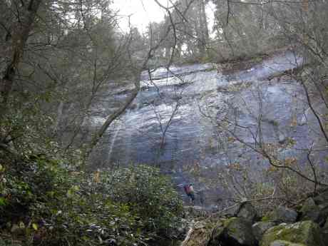
Finally we came to the largest cliff of all, a menacing-looking brow of rock about 100 feet high, smooth and shining, water cascading down it. As we gazed up at this obstacle, we noticed a dead mouse lying near our feet. We speculated that it had fallen over the cliff. The rockface was split by a narrow ledge that Peter and Brian had crossed on their 2008 expedition. As we looked for a way to scramble up to reach the entry point of the ledge, Peter lunged upward to grab a rhododendron trunk and dislocated his shoulder. We were all in suspense for about ten minutes as Peter lay on his back and Brian experimented with gently moving Peter’s arm. Finally the misplaced shoulder popped back into place. It turned out that Peter has a chronic problem with that shoulder, although it certainly hasn’t slowed him down in his many exploits, such as climbing all the southern 5000-footers, writing a book about North Carolina fire towers, and doing the 900 miles of trail in GSMNP.
We found an alternative route up to the ledge by heaving ourselves up from one strategically placed rhododendron to another, then worked our way across. Josh, an experienced rock climber, was the first to go, and I was next. Toward the end of the ledge Josh crawled on his hands and knees, and I followed his example. The drop to the right was tremendous. The strange thing is, it makes my palms sweat when I think about it now, but at the time it didn’t seem so bad. As I’ve mentioned before, I seem to get into the flow of the movement when I’m actually in the thick of it, even though I would describe myself as afraid of heights.
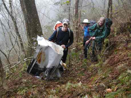
Up and up with our heavy packs, into a cool gray mist that had wrapped around the mountain. Suddenly Peter called out that he saw a piece of metal! We had come straight to the plane crash site! As we moved closer, amorphous shapes resolved into distinct components of an aircraft. Most poignant among the rubble of the small two-seater plane was the rusted pilot’s seat with its metal frame that stood in a nearly upright position. Pieces of debris were scattered far around.
We did not have much further to go to the overgrown top and to the one spot on the summit ridge that makes a decent campsite. We had a 3-man tent, a 1-man tent, and a hammock. As the dusk deepened, Brian quickly set to work starting a fire, which seemed incredible to me: it seemed he had nothing to work with but damp, rotten wood. Brian is very much a “can-do” person. A tall, strong fellow with an incurable love of adventure, he has bicycled in China, climbed volcanoes in Ecuador, bushwhacked through tropical jungles in Central America, and generally penetrated into the gnarliest regions of the globe.
It was when we reached the top that Brian finally discovered the small Halloween pumpkin that Peter had secretly stashed in his pack.
We had dinner and exchanged atrocious puns around the campfire before retiring for the night. The rain and the wind were picking up. The towering spruces with their dense crowns swayed and sighed, and I noticed just before entering my little tent for the night that I had pitched it under a precariously leaning tree. But there was no other place to put it. During the dark hours, raindrops seemed to come in angry bursts, as if being hurled down on the tent.
I was somehow not surprised the next morning to see Brian starting a fire in the rain, although it was not as successful as the one of the night before. We shook the water out of our tents as best we could—Paul folded the tarp that had maybe not quite protected him in his hammock— and packed up to go. Soon we were descending to the Woolly Tops/Laurel Top col and working our way into an upper tributary of Eagle Rocks Prong. The rhodo quickly tightened into a giant impenetrable knot. I would stomp down on a coiling, snakelike lower branch only to become entrapped by a higher one that seemed to clutch the top of my pack. Seeking escape from this diabolical thicket, we went to the stream. Though Brian had been able to rockhop down it easily on an earlier trip, now it was a rushing flow of churning brown water.
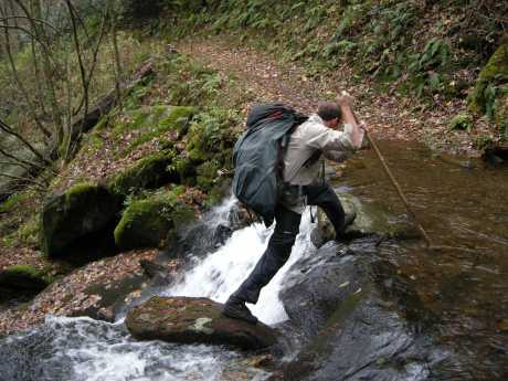
It seemed that the best route lay in the stream itself, even though that meant deep wading. We still got stuck in the grasping rhodo that overhung the stream. From one bank to the other, then down the middle, sliding down mini-waterfalls, then on the side again, we fought our way along. I probed with my pole to determine the water depth, but more than once found myself suddenly dropping into a hip-deep pool.
We stopped for a break and checked the time. (I was able to look at my watch thanks to Paul’s miraculously finding it on a fallen log after the rhodo tore it off my wrist.) Noon already! It had taken us a couple of hours to go well under a mile, and our rate of progress had deteriorated. We still had a very long journey along the tributary stream, then up the main branch of Eagle Rocks, to get to our planned campsite. (No pictures on this section—we were too busy hiking.)
We all seemed to realize simultaneously that our original goal was simply impossible under these high water conditions. The decision to make for the nearest trail was disappointing but unanimous. Around we turned, bearing southwest toward the A.T. After climbing and clawing our way up about 1500 vertical feet, we reached the Laurel Top ridge and burst out of the brush onto the A.T. We were two miles west of Pecks Corner.
We passed Pecks Corner and pressed on another five miles to the shelter at Tricorner Knob. I was feeling hypothermic in the cold rain. I had a dry top and dry socks to change into, but no other pair of pants. And socks would not stay dry very long if I put them into my waterlogged boots, so I put white-banded stuff sacks around my feet, which Brian said gave me the appearance of a Clydesdale.
After eating a bowlful of delicious mulligatawny that Josh had prepared for all of us according to his special recipe of rice, chicken, curry, and apple slices, I retreated into my sleeping bag, closing it up over my head. It was a shivery night punctuated by the rumblings of obese mice among the beams of the shelter and the pelting of rain on the tin roof.
The fog started to clear in the morning. We had something important to do: put on our Halloween masks—it had been too dark and cold the night before. The only other occupant of the shelter, an affable fellow who was heading south along the A.T., took pictures of us in our masks. For an audience we had a tame guinea hen that seemed to have adopted the shelter, pecking at bits of hiker detritus. None of us could come up with a plausible theory about how it had arrived there.
We continued east along the A.T. Some of the evergreens had sparkling crowns of hoar frost. From Deer Creek Gap we could see islands of hulking ridges rising through an undercast: Luftee Knob, the Plott Balsams shining pale blue in the distance.
From there it was a straightforward journey to the Snake Den trail and Cosby campground, where we had a shuttle car waiting. Almost at the end, we met some hikers who told us they had just seen a bear. And there he was, a big black furry shape that lumbered off when we approached. He had been rooting in the ground for acorns under a giant red oak, digging a big hole with his paws in the soft earth.
I knew it had been one of those adventures that settles deep into the memory. Those few days had flowed past in brilliant clarity.


Jenny, sounds like quite the adventure; at least the camera went down in the line of duty. Wow, must have been a moment seeing that wreckage.
Hi Mike, yes, it was great stumbling upon the plane wreck, especially since it was late in the day for us and we had been working very hard getting up that stream. The fog that was coming in at that point made it seem all the more mysterious, as we all thought about that crash happening 65 years ago.
I read this before the photos arrived, and enjoyed my armchair adventure in the Smokies. All I can say after seeing the photos is, “Good night!” You’re an intrepid bunch.
glad you found the plane wreck-i’ve been up there a few times but haven’t stumbled across it yet. and i haven’t encountered the rock faces that you did, but have surely gotten bogged down in virtually unpenetrable tangles of blowdown and undergrowth. i really like heading up the steep flanks above the (two) big poplars. there are some great ramparts ‘guarding’ the summit ridge. now i want to get up there again.
several of us did a nice trek along the county line ridge from west of 12 oclock top to mt pisgah the other day. it was super to climb that peak from the west. a couple grandstand views along the way-mostly private land-one colleague had obtained permission to hike.
Yikes, I used to think I was a serious hiker. The folks who did this hike are thin as whippets and game as pitbulls! What an epic hike. You all have defined the term “exreme hiker.”
Make sure you invite me if you ever hike the Laurel Falls trail!
:^)
Seriously, congradulations to everyone on this hike.
After all that toil, you then all had to deal with a clearly perturbed chicken.
Would have been too much for me!
The photos truly complete the deal.
You have inspired another group of hikers to follow your route up the mountain and find the plane wreck. Four of us did so yesterday and navigated the sheer walls to find the plane wreck. Three of us found a route to the right to avoid the narrow walkway at the 3rd wall, while Greg, our 4th hiker sought it out and crossed it twice just for fun. We had decided to day hike (I would not have wanted a heavy pack yesterday) and returned down the ridges between Wooly Top Branch and Kalanu Prong. It was a long day, darkness overtook us before we had reached the old roadbed along False Gap Prong. Mike Harrington referred to our “candlelight procession” down the mountain as enjoyable except for the first part which was steep and greenbriar infested. Loved the pictures.
Terri
I’m impressed that you got in and out in one day when the daylight hours are so short, even if the last bit was in the dark. But the weather was absolutely beautiful yesterday, so that would have made it enjoyable. I’m glad that people are looking at these posts and actually doing these hikes!
Jenny
Always looking for great new places to explore in the offtrail wilderness. We know some people in common after looking at other parts of your posts, maybe we have hiked together in the past. I love that you include backpacking in your offtrail adventures, something I have only done once.
Terri
Wow, that is quite a dayhike Terri! Sounds like something only SMHC crazies would take on. Hehe, I noticed the right side looked a lot easier as well, but didn’t say anything to the rest of the group. Didn’t want anyone to miss out on “Freakout Ledge”. Perhaps I will get a chance to hike with you all sometime. I’m hoping to make a club hike next year.
I just assumed that there was probably an easier way to go but that the ledge was a key part of the total experience! Sort of like crossing the ledge partway up the big waterfall at (I think) 4400 feet on Cannon Creek. Not necessary, but worth doing anyway.
Hi,
I met Dwight McCarter for an Interview (I am a Travel-Journalist from Germany). The Interview is for a Radioshow, but I would love to use your foto of Dwight for my manuskript. Would you possibly allow me to use it? That would be wonderful.
Thanks a lot, and all my best wishes from Germany
Cordially
Rudi