Right fork of Trout Branch December 2, 2013
Posted by Jenny in bushwhacking, hiking, Smoky Mountains, winter hiking.Tags: Alum Cave Trail, Mt. LeConte, Trout Branch
trackback

We looked back down from the top of the big waterfall.
I’ve been up Trout Branch maybe four or five times over the years, but I’ve always gone to the left at the major junction just below 4400′. Most times I’ve gone up what you might call the right fork of the left fork, the one that leads up to the Alum Cave trail directly below Cliff Top. Once I took the left of the left, which goes to the West Point ridge. The right fork was the only one I hadn’t explored.
I was accompanied by Cindy McJunkin and Chris Sass on this fine outing. They are great hiking companions. Chris and I have done a lot of hiking trips together, but this fall he’s been swamped with work at his teaching position at Young Harris College in north Georgia (he teaches math). He hadn’t been able to get out for a good bushwhack adventure since August… way too long. Cindy has been bitten by the off-trail bug in the past couple of years—she’s an experienced backpacker who’s put in a lot of mileage on the A.T.—so I was glad she was able to join this outing. Fellow female bushwhackers don’t come along all that often.
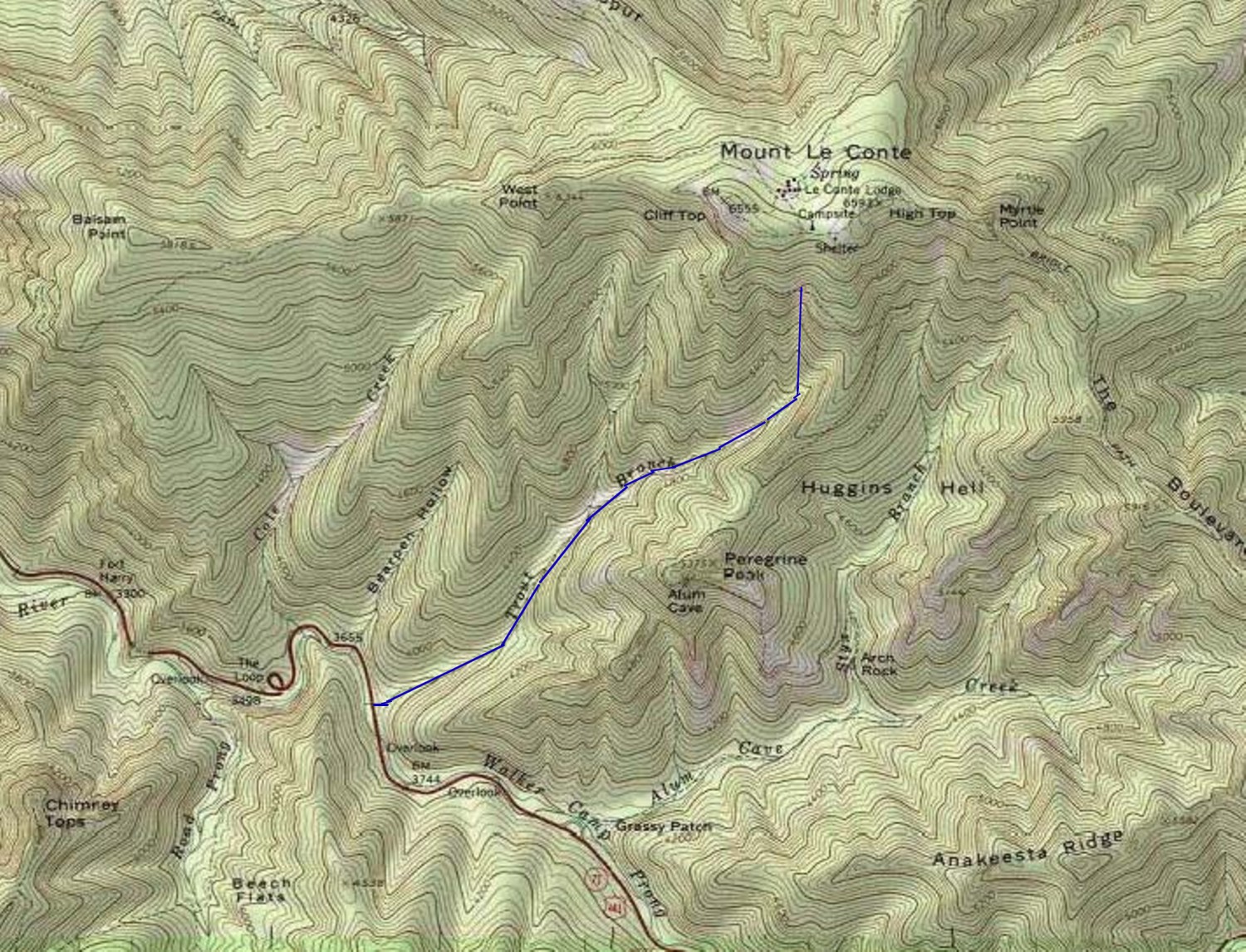
Our route up Trout Branch. It terminated at the trail, a dotted line hard to see on this map. Click for zoom.
We started a little after 9:00 and proceeded up the lower stream. Even in this photo you can see a hint of red discoloration on the rocks caused by landslide activity that exposed sulfuric Anakeesta bedrock.

Look closely, and you’ll see a faint reddish tint on some of the rocks.
As we got closer to the base of the big landslide, we could see patches of the “tomato soup” water that you encounter after these cataclysmic events. For photos of a trip up the slide, go here. Recent heavy rains have diluted the water.

Now we get into the “tomato soup.”
The logjam at the base of the slide is just amazing.

These were living trees up till the landslide, which snapped them off and stripped off the bark.

Bottom of the slide chute.
The slide is fun to climb in dry conditions. In the ice and snow we encountered this day, it would’ve been pretty challenging.
All along the stream I enjoyed the ice formations.

Snow and ice over water.
There is a particularly beautiful pool a little above the landslide junction.

- Chris approaches the pool.

A place of dreams and imagination.
We had a treat a little further along: paw prints in the snow.

- Bear prints in the snow.

The bear walked across the snowy log.
We saw a large waterfall ahead. In this photo you see the sunlight hitting the treetops above. We were in and out of sunlight in this stream valley.

This was a significant obstacle.
We did some serious rhodo thrashing to get around the waterfall and finally got to the top, where the photo at the top of this post was taken. We got into pitches of steep terrain.

Looking down the slope.
At around 5100′, several small valleys converge, some too small to show up on the map. At first we stayed with the largest, easternmost valley, but when we reached a point where it was clogged with blowdowns, we opted to follow a draw that angled to the left, going close to due north.

Cindy and Chris work their way up the valley.
We got into a fun bit of steep rock scrambling. When we reached smooth icy ledge we headed off to the right and got into steep spruce forest. From there it was a strenuous but straightforward climb up to the trail.
We’d thought we might cross the trail and continue upward along a valley that in days past was used as a descent route by LeConte Lodge workers. However, sunset comes so early these days that we opted to head down, and it was a good thing we did, for it was getting dark by the time we reached the lower sections of the Alum Cave trail. Can you believe it took us from around 9:15 to 2:30 to go something like two miles on the off-trail portion? If you figure we’re especially slow or inept, I invite you to try it for yourself, in similar conditions of snow and ice.
As we descended the trail, we met J.P. Krol, the winter caretaker of LeConte Lodge. Most likely he was entertaining himself with a trip down to Alum Cave Bluff.
A great hike with two fine bushwhacking companions.

Cindy took off her pack to squeeze under this log.


Jenny,
A few years back Terri Cox and I did almost exactly the route you did.
At the very top just before we hit the trail, we veered slightly to the right of where you went, but other than that my GPS track is virtually a copy of yours. To make you feel good, it took us at least 2 hours more than you all took. Like you we went left and due north because of what looked a massive mess of deadfall. Our trip was long before the recent slide. You are going to ruin Cindy, she will get like the rest of us and won’t be happy on trails anymore,
Laughing,
Clyde
Interesting that you and Terri made the same choice to go left at that point. I wonder if anyone has been up that route between when you did it and we did it!
7774Jenny, it has always struck me as interesting, but when I do off-trail routes that are reruns, I invariably find that I go around obstacles etc the same way. No even intentionally, just seem to do it. The terrain and “stuff” just sort of carries us in a certain way. Sometimes I think that means making the same mistake twice!
Jenny….thanks for sharing the hike! I was up that way this weekend….but didn’t do anything “off trail” as my wife was with me. It was beautiful with the dusting of snow.
Best…..Steve
Beautiful pictures .. after our hike Friday, the visiting dog Oji
didn’t move much. The party went okay, band size went to 7.
Since then Ken has enlarged it to 8. Zach and my mom left this morning and .. oh no, it’s back to work.
It was great to see you. As often, I klutzed and didn’t offer you the nuts and apples for your drive home. Oops.
Best,
Gary
No problem about the food for the drive. I had Nadia’s sampler plate with Thanksgiving leftovers. Near Winston-Salem the brilliant setting sun in the clear sky was creating visibility problems, as the highway headed straight in that direction. I pulled off at a rest area and enjoyed turkey, vegetables, and pie for about 15 minutes until the sun sank below the horizon.
Jenny: Great image of the pool, with the rhodo leaves reflecting on the water. Next time, I will know to crawl under logs only when you and your camera are in front of me! I can’t figure how you crawled under with your pack still on your back….
Cindy, thanks for the comment about the photo of the pool. Regarding that bottom photo, I used it because it gives a good picture of the contortions required in off-trail hiking. It’s never my intent to capture anyone in an unflattering light, and I honestly don’t think this photo makes you look bad, more like intrepid in dealing with the obstacles. I can crawl through tight spots with my pack because I slither in an undignified manner on my belly… something I’ve often done in the Smokies backcountry!
Jenny: Actually, I like the photo and appreciate how you were able to show the challenge of moving through the obstacles. Let’s go again soon, so I can try this slithering through a tight spot!
Funny, I always lament that we don’t get enough photos of the nasty spots and salad. All the photos end up being the open hardwoods and “view” spots. Never the tangle and mess. Then when I show the photos people wonder where all the mess is! While I am crawling and struggling I never take a picture!
Another excellent write-up about a fantastic outing! I’m glad you and Cindy got some good pictures since I forgot to bring my camera.
Good for Chris for making time to get out there. Doing better than me! Have to smile thinking about that bear walking over that log to keep his feet dry. A dream of mine is to go out after a fresh snow with three days supplies and do nothing but follow the trail of a single bear in a remote part of the Smokies. I spent many hours following tracks on that long snow bushwhack that you and Seth started off with me. They are good at picking out a route, or maybe they just follow habitual paths. You think they’ve gone wrong and then you realize what you thought was right heads straight into a log choked ravine. One bear even led me into a rock tunnel that went 50 feet right through a narrow ridgeline.
Brian – Jenny and I were talking about you on this hike and agreeing that we should organize another OT backpacking expedition in the Smokies next year. We discussed an OT traverse, something like up Little Niagra and down Ramsey.