Mt. Cammerer via Miner’s Stairs October 19, 2013
Posted by Jenny in bushwhacking, hiking, Smoky Mountains.Tags: Leadmine Ridge, Mt. Cammerer, Rowdy Creek, Smoky Mountains Hiking Club
11 comments

Blake tackles one of the Stairs.
Today the Smoky Mountains Hiking Club made its annual assault on Cammerer via an off-trail route. Each year the club offers one trail hike and one bushwhack on the same day in October to this mountain that is always a favorite.
Three years ago the SMHC climbed up Leadmine Ridge to Cammerer. That is one of several parallel ridges on the north side of the mountain. This year’s offering overlapped with that route to a certain extent, but we climbed up Rowdy Creek (the stream just east of the ridge) past the waterfall before getting up onto the ridgecrest.
Despite having been up both Rowdy Ridge and Leadmine Ridge, I’d never been up Rowdy Creek. The waterfall is pretty, though in the current dry conditions it wasn’t spectacular.

We approach the waterfall.
We found a route to the left of the falls that used a narrow seam between chunks of bedrock. The route would have been easy except for the peculiar quality of the soil in these parts, a very slippery dark brown substance that I always think of as “chocolate pudding.” It is exactly the same soil that has made the Groundhog Ridge manway such a mess. I think the first person climbing has the advantage, because that person’s footprints turn into chocolate slime, and for each person after that it gets progressively slipperier. So it becomes a matter of finding a rock here and there for a foothold and a branch here and there that can serve as a handhold, if it doesn’t come off in your hand.
We passed through a beautiful boulderfield where each boulder sported a wig of rock polypody fern.

It was really neat how each rock had this crown of ferns.
We encountered a tree that had the slimiest, most repulsive fungus that I’d ever seen.

Yum! Just the thing to put in your omelet!
Ed Fleming, our leader, had determined what he felt was the best elevation to leave the creek and get through the rhodo that guarded the ridgecrest. We had 15 or 20 minutes of pushing through fairly dense laurel and rhodo before we reached the Stairs. Speaking of Stairs, we had a nice view over to the Panther Stairs, the next ridge over.
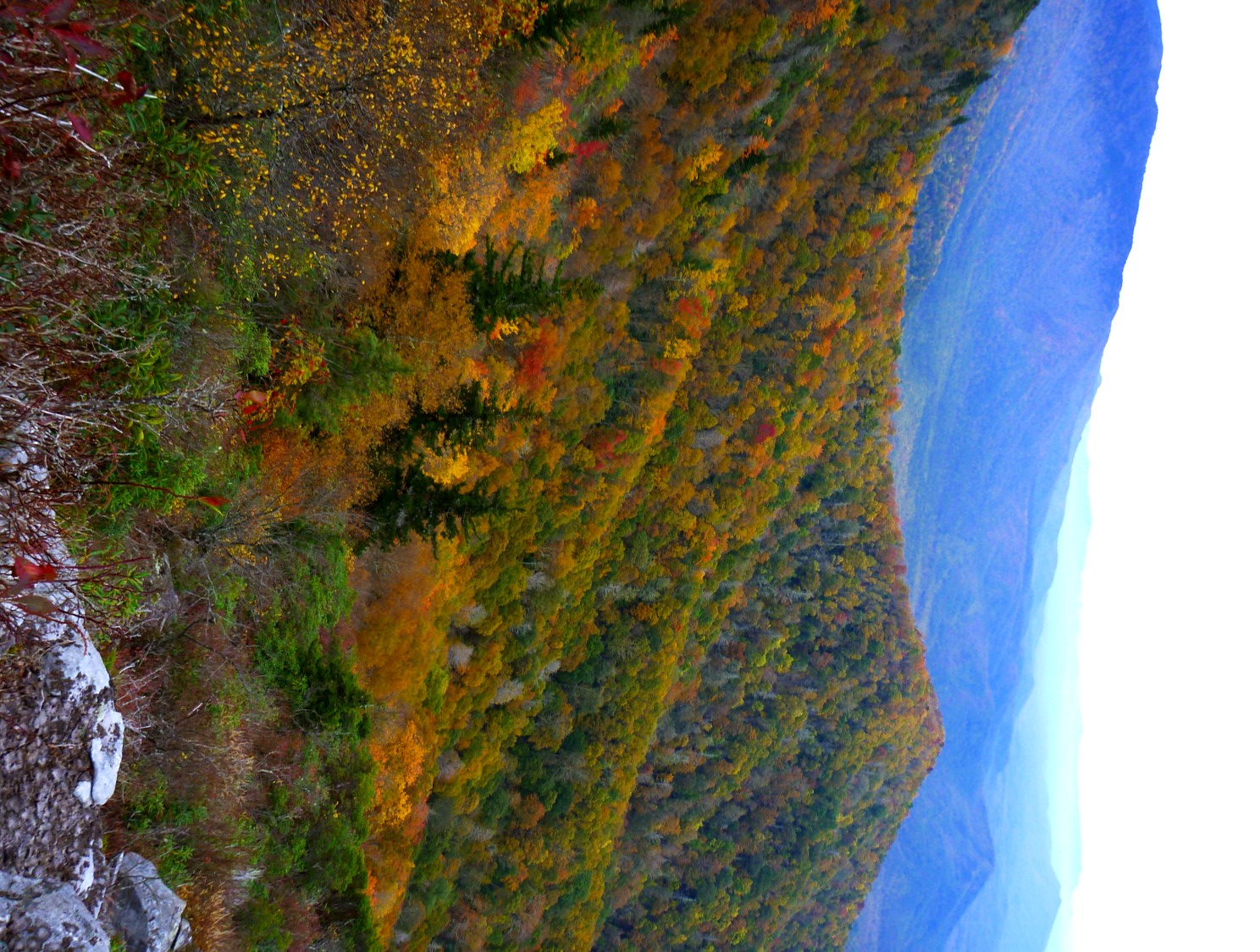
Even though the sky is overcast, aren’t the colors wonderful?
We climbed the Stairs up the ridge.

- Going up the ridge.
Every now and then I’d look over my shoulder and enjoy the colors.

I feel so fortunate to have views like this.
As soon as we reached the Cammerer side trail, the clouds moved in—we were lucky that didn’t happen earlier. We had lunch at the tower and serenaded David with Happy Birthday, as he had just turned eighteen.
We descended the Groundhog Ridge manway, which becomes more and more annoying every year. The “chocolate slime” gets worse and worse, and quite a few new blowdowns have added to the mess. Still, it remains the best way to descend Cammerer from any of these other great off-trail routes on the north side of the mountain. A fine day with good hiking companions.

The clouds move in.
Grandfather Mountain—eastern side October 14, 2013
Posted by Jenny in hiking, Southern Appalachians.Tags: Calloway Peak, fall foliage, Grandfather Mountain
4 comments

The conifers seemed to be marching through the mist.
Somehow or other, over the years, I’d missed out on Grandfather Mountain. I’d heard many times about the famous swinging bridge, the grandfather profile, and the rugged trails. I’d driven past it on the Blue Ridge Parkway. Yesterday my friend Gary and I visited the area’s eastern end and climbed Calloway Peak (5946′).
Several years ago, much of the area, long privately held, became part of the North Carolina state park system. The western end, with the swinging bridge and nature center, remains a private attraction with an entrance fee. Gary and I decided to access the park for free from the Boone Fork trailhead on the parkway,
We followed the Nuwati trail to its end, backtracked to the Cragway trail and followed that to the Daniel Boone Scout trail. We then continued westward to Calloway Peak, backtracked on the Boone trail, and descended to the Tanawha trail near the parking area. The trail system is somewhat complicated.

I loved this sign.
Our hike was about 10 miles with an elevation gain of 2000′. Much of the time we were in the spruce-balsam zone. The forest resembles other high-elevation areas in the Southern Appalachians, including the Smokies, but something about it looked different to me. I had a hard time putting my finger on it, but I finally decided that the vegetation is simply smaller and sparser than the familiar environment of the Smokies—no big surprise considering it’s further north. This doesn’t mean the Grandfather Mountain forest is less attractive than the Smokies forest. You could even argue that the Smokies vegetation is so dense and the trees and plants so chaotic and oversized that it’s, well, kind of messy-looking. I happen to like that, but… that’s just me.
The feeling of a tidier environment extended to the trail itself, which features many wooden steps and neatly crafted drainage systems. It also has ladders on some of the steep ledges.
The Nuwati trail had some nice overlooks.

The red maples were spectacular.

Gary enjoys the view.

Looking down into the bowl.

Interesting rock formation.
We left behind the views and entered the mossy, misty conifer forest. I spotted these ferns growing in a crevice in a large boulder.

Polypody ferns.
As we approached Calloway Peak, the way grew steeper and rougher. Some minor scrambling was required, and we encountered three ladders fixed to steep places. On our way up, at one of the longer ladders, we met a man and woman descending. She was having a tough time with it, and descended facing outwards, which I believe made it harder. Eventually we topped out on Calloway.

View from Calloway Peak.
After resting for a while on the summit, we went back down the ladders—facing the rock.

Gary descends a ladder.
We had a few spots of drizzle, but the rain held off until shortly after we returned to the car and started driving down the parkway, when it poured. I liked the clouds and the mist—it was a fine outing.

Fall colors.
An illegal walk in the park October 11, 2013
Posted by Jenny in hiking, Smoky Mountains.Tags: Appalachian Trail, Charlies Bunion, Government shutdown, Newfound Gap
5 comments

We started before dawn.
I had a guest staying from out of town, and we were in the mood for civil disobedience. It was a no-risk proposition: I knew that after the first couple of days of the government shutdown, the park rangers were allowing people to walk from the Newfound Gap parking area past the orange barrel on the A.T. that says “CLOSED.”
The A.T. going either direction from NFG is, in effect, the only accessible trail within the park, though it is quite possible to get to other trails by walking on gated roads or by parking close to one of the barricaded trailheads on 441 and walking a short distance. Don’t try to bicycle on a gated road, though, for the Park Service considers that a “vehicle”—Jeff George, a follower of this blog, cycled all the way from Gatlinburg to NFG but was stopped when he tried to continue up the Clingmans Dome road.
And of course one could do a bushwhack from a non-trailhead pullout on 441. But my friend Maryanne is not a bushwhacker. Walking the A.T. to Charlies Bunion was virtually our only choice. We decided to make it more interesting by going very early.
We started hiking at 7:00. I led the way with my headlamp, and Maryanne carried a small flashlight. By the time we reached Mt. Ambler, the headlamp wasn’t needed any longer.

View near Sweat Heifer junction.

Sunbeams breaking through.

We were in and out of mist.

Witch hobble leaves.

The Bunion.

Horseshoe Mountain.
It made me feel sad to look over to Horseshoe, since I haven’t had the opportunity to get back over there for another try at climbing Horseshoe Branch following my unsuccessful attempt. If I don’t have a chance to do it soon, the daylight hours will be too short. It’s hard to say which way is harder, going from Porters Creek or from NFG (from the latter point, I would drop down from Dry Sluice Gap).

This zoom shows the slide. I was below the bottom of it when I got stung by wasps.

View toward the east.

View toward the Jumpoff.
But it was great to be out on a fine early morning. We saw no one until we were nearly back to the trailhead.


