My new hiking tool January 19, 2015
Posted by Jenny in bushwhacking, hiking, history, Life experience.Tags: analog altimeter, compass, digital altimeter, GPS, off-trail navigation, Peet, Thommen
10 comments
Actually, it’s pretty old… but in this case that’s a good thing, because this is rare and valuable.
Everyone who explores off-trail with me knows that I use map, compass, and altimeter and don’t own a GPS. If you are curious about this preference, please read this piece, which I wrote in late 2008. That was toward the end of my long sojourn in New England, so you will find references to oddities like the severe magnetic declination in the Northeast.
At that time, I still owned an analog altimeter. It was a Peet, the second one I owned. An earlier Thommen had been lost. The Peet got drowned after I returned to the Smokies area and waded up Lester Prong (I’ve also drowned a camera there). And I found that I was unable to replace it, due to the now-complete dominance of digital devices of one sort or another. All I could find on the market was crude altimeters with very large increments of elevation, some meant for skydiving. Because smaller means more precise, you don’t want anything more than 20′ increments.
I’d also been using a digital altimeter on a lot of hikes. I do like the multiple functions of these devices, the ability to do things like get your cumulative elevation gain or fun-but-totally-unnecessary things like set an alarm to go off when you’ve reached 4000′. But they have never been as accurate as the mechanical altimeters.
So I reluctantly accepted that the older ones were extinct, and I’ve gone through several digital altimeters. They always seem to start going wonky well before the battery dies, and they are severely affected by temperature. Check your wristwatch altimeter in a warm car just before you get out into near-zero temps, then check it again. You’ll see what I mean.
In the meantime, GPS technology just keeps getting better and better. I remember folks trying out the early models in the mid-1990s and practically heaving them into the woods with frustration, often for lack of satellite coverage.
I don’t hate GPS units or think they’re “cheating” or somehow inferior to traditional technology, though I do believe that everyone who uses a GPS should also know how to use map, compass, and altimeter in case something goes wrong. A compass never goes wrong unless you’re in weird magnetic terrain or unless the compass becomes mechanically broken (that did happen to me with a 25-year-old compass). My only other hesitation about GPS use is that folks sometimes seem to look at the unit more than they observe the terrain.
I admire the wonderful tracks and maps that people produce with GPS and associated software. And I see how GPS is especially useful for people pinpointing very specific locations such as old homesites.
Anyway, there was recently a discussion about all this on the “GoSmokies” forum. I put in my typical comment about my method of navigation: in the Smokies I use altimeter more than compass to locate points like specific stream junctions where I know the elevation. At the end of my comment, I mentioned that if anyone had an old analog altimeter, I’d like to buy it. And someone responded! A very nice guy named Dan G. was willing to part with an old but top-of-the-line Thommen altimeter.
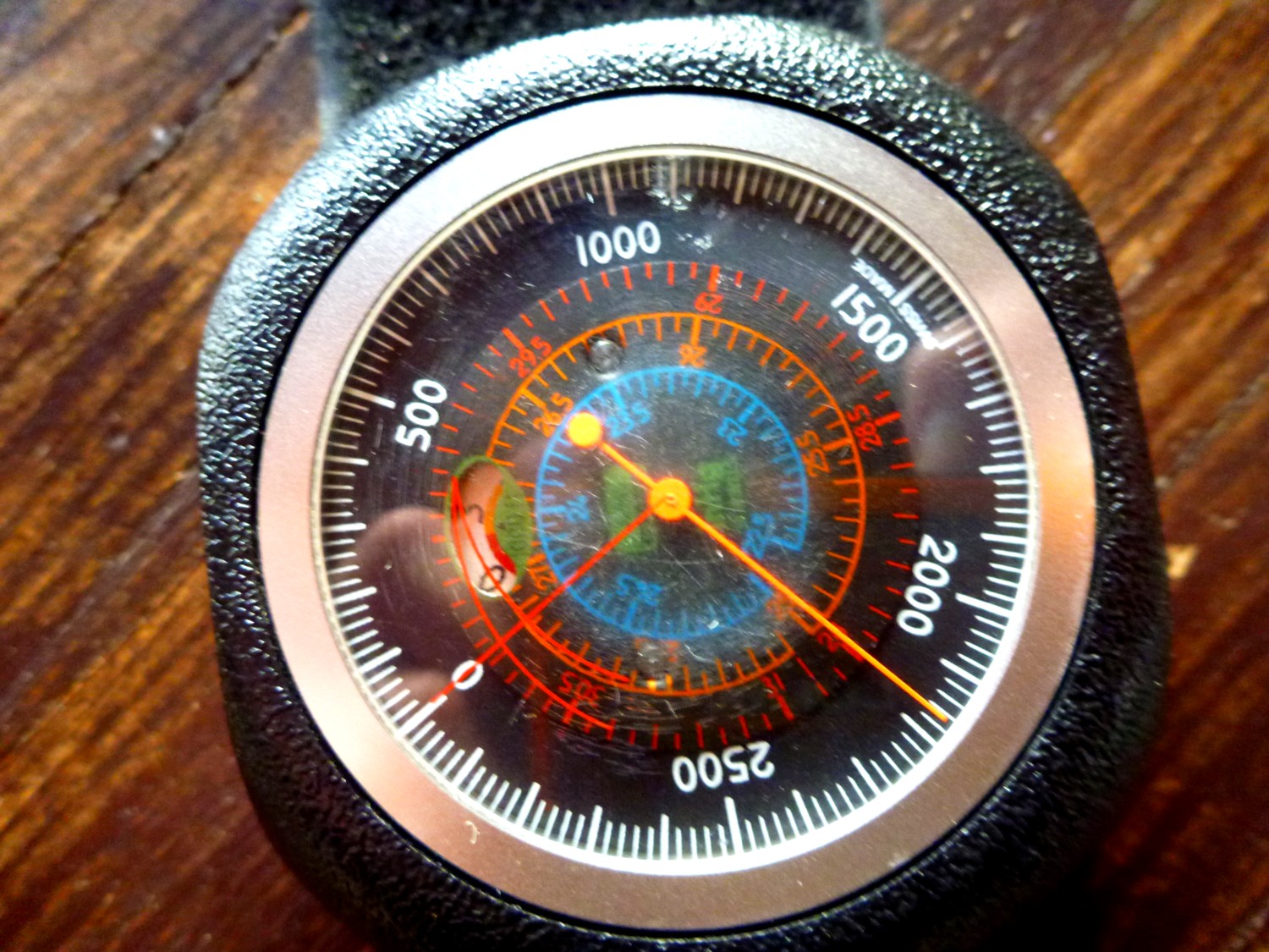
I immediately wondered if it had the wonderful feature of my old Thommen: a small window that changes color each time the needle makes a circuit of the 3000′-dial. A little below 3000′, it shows red to alert you that you’re moving up to the next circuit; below 6000′, it shows yellow; below 9000′, it shows blue, and so on. And it DID have the window, plus some features related to units of barometric pressure that my old one didn’t.
You may ask what’s so wonderful about a little window that shows color. Well, it’s because the dial can’t show more than 3000′ since any larger amount of elevation would take up too much space. Suppose you could see up to 10,000′ with one revolution of the dial. Can you imagine how small the markings would have to be—or how large the dial would have to be?
I know, so much easier to have a rectangular screen with numbers that change digitally. But you miss out on the beauty of a complex and ingenious mechanical device. And…it has no battery. Hah!

Closeup of the small window.
In the photo above, you see red disappearing to the left and a tiny bit of blue coming up on the right. We are a little more than two-thirds between the 0 and the 3 because the photo was taken at my house, which is at elev. 2160′. You can see that in the top photo.
Bushwhack to Chimneys January 16, 2015
Posted by Jenny in bushwhacking, hiking, Smoky Mountains.Tags: Chimneys
18 comments

The inner (tourist) Chimney always looks imposing from the outer Chimney.
I believe this is the fifth time I’ve climbed off-trail to the outer Chimney and then made the traverse to the inner Chimney, the one that’s at the end of the maintained trail. My friend Clayton had not done it by that route, so we decided to do that trip.
It was an overcast day but with temperatures above freezing. Not bad conditions for doing a trip that would be pretty difficult in icy conditions.
Since we did have subfreezing temperatures in the past week, we noticed that it was easier to see all the cascades in the area, now white with ice.

Not a great photo, but you see how the surrounding cascades show up with all their ice.
We climbed up to the ridge that runs north of the outer Chimney and made our way out to the knob where you find a giant cairn. I consider this the #2 best cairn in the Smokies. The #1 is located on the Porters Creek manway just where you start climbing up very steeply. That one is so huge and well-constructed that folks call it the “Mother Cairn.” Well, this one ain’t so bad either.

The second-best cairn in the Smokies. A great one, only outdone by the one on Porters Creek manway.
Something funny happened at that point. Just as we approached the knob, which is covered with pretty dense laurel, Clayton and I went in different directions. I made my way to the cairn, having been there before and knowing the way. I got there… and waited… and waited… and Clayton didn’t show up. I started calling his name, and he didn’t answer. That area has some really stiff dropoffs, and I started thinking he had fallen off the edge somewhere. I called again, and he still didn’t answer.
So, Clayton must have gotten killed falling off a cliff, I decided. I started thinking about the process of contacting the rangers.
It turned out that he was having exactly the same thoughts. He was on another edge of the knob, calling my name, and finally deciding I had gotten killed falling off a cliff.
Even though we were, I would guess, around 20 yards from each other, we couldn’t hear each other. Finally I climbed back up to the top of the knob and called out, and I got an answer. What a relief! It was actually really funny.

Clayton, alive and well at the cairn.
We made the fun climb up to the outer Chimney. Generally it works best to go to the left where you hit the bluffs.

Clayton took this picture of me approaching the top of the outer Chimney.
We made the traverse over to the tourist Chimney, and Clayton explored one of the interesting holes on the top. It’s tricky in there—not too hard to go down or up, but there’s a side where you could slide into outer space. I’ve done it before and didn’t do it this time.

Clayton in the hole.
You might notice he is wearing a Dallas Cowboys hat. Folks who follow the NFL know that the Cowboys lost to the Packers last weekend in the playoffs. I watched that game. It was one of those games that was probably decided by a questionable call, concerning whether a pass into the end zone was complete. Clayton was pretty sick about that, and I could totally understand. People who aren’t into sports think it’s kind of silly to get so wrapped up in these things. As I’ve said before, I believe sports is one of the few areas of our lives that concerns a true contest of human beings, totally unlike the artificial political or pop-culture realms. Clayton was generous enough to say that he’d be in favor of my team, the Patriots, since his was now out of contention. We’ll see what happens this weekend against the Colts.
We didn’t see a single other person until partway down the newly reconstructed trail. We got closer to the bottom on all those new steps. (I’m not so sure they are necessary. Water drainage yes, steps too close together and too short, no.) There we saw a few more people. I’d guess we saw eight or ten people total on the trail.
I always like noticing the exact spot where Road Prong and Walker Camp Prong join to form the West Prong of the Little Pigeon River. Just call me a geography nerd.
It was a great hike.

Looking up Road Prong from the bridge, just above the junction.
Cold-weather climb to Fox Hunters Camp January 8, 2015
Posted by Jenny in bushwhacking, hiking, Southern Appalachians.Tags: East Fork of Fisher Creek, Fox Hunters Camp, Plott Balsams
5 comments

View to the southwest from Fox Hunters Camp in the Plott Balsams.
The plan for today was to join Clyde Austin, Mike Harrington, and Frank March for a bushwhack along All Night Ridge, which parallels Anthony Creek in the Cades Cove area of the Smokies.
But the Park Service had other plans. At sundown yesterday, they closed the Newfound Gap Road. There was only a dusting of snow yesterday despite cold, blustery conditions, but the thinking seems to be that black ice might be a hazard overnight. Having seen this pattern before, I figured they’d probably reopen it around 9:00 the next morning. And they did—just about 9:00 on the nose.
That didn’t do me any good. I had to meet my friends at 8:00 at the Anthony Creek trailhead. To get there on time from my house in Sylva, NC, I would have needed to drive past the Smokemont gate around 6:00.
I’d been looking forward not only to hiking on a ridge where I hadn’t been before, but using my cold-weather gear. The forecast was for temps near zero in the early morning. I’d dug out my heavy parka, my heavy mittens, and my Sorel boots, which haven’t been used much since I left New England. Never mind.
I woke up to a temp of 4 degrees at my house and decided I’d wait till things warmed up a bit and do a hike I’ve done many times before in the nearby Plott Balsams. You climb from 3000′ at the trailhead to about 5000′, where you find an open spot known as the Fox Hunters Camp. And you pass a beautiful waterfall that’s just a little bit off the trail. I’ve featured it often in this blog. But I never get tired of it, especially in icy conditions.
I figured I’d do the side trip to the waterfall on the way down. I headed up the steep East Fork trail, plodding along with a heavier pack and more layers than usual. It turned out I was overprepared. The temp at the trailhead was in the upper teens when I started, and I didn’t really need the snowpants or the down parka. Another weather system was coming in, and things warmed up rapidly.
It was so pleasant at the Fox Hunters Camp that I just relaxed in the sunshine for a while. There was no wind.

View toward the ridge of Pinnacle Bald. Note the big, smooth cliff on the side of the ridge.
I descended, passing lots of rhodo that had gone droopy in the cold. It always bounces back with a vengeance, growing more ferocious than ever. If you bushwhack in this part of the country, you know what I mean.

It looks wilted and unhealthy. This is an illusion.
I reached the really steep part of the trail and turned off on sort of a bench in the hillside to reach the waterfall. There’s no trail, but it’s quite a short distance.

Big icicles close to waterfall.

The waterfall shows off for the camera.
I’ve visited the waterfall in all levels of waterflow and all degrees of iciness. Today, it was not iced over as completely as I saw it last winter—it takes about four or five days of continuous severe cold for that to happen. A sort of tube of ice forms over the whole thing, with just a narrow slit where you can still see the water flowing, almost as if designed so that the viewer can appreciate the living water in contrast to the frozen mass.
But today offered something good, a high level of flow from some very heavy rains we had not long ago. At any rate, it was beautiful.
Below the upper section of the waterfall I noticed an interesting ice pattern.

Odd ice shape.
I gazed down to the sunny lower falls before continuing on my way. Always a worthwhile trip.

What looks at first like foam is ice with a cauliflower texture.
P.S. I am adding some info at the request of a viewer.
Photo:

Flat area of the camp.
Map:

X marks the location. Click for zoom.

