You think it’s cold? March 24, 2013
Posted by Jenny in hiking, White Mountains, winter hiking.Tags: East Kennebago, Middle Carter, Mt. Adams, Mt. Eisenhower, Mt. Jefferson, Mt. Lafayette, Mt. Madison, Mt. Moriah, Mt. Washington
8 comments
I’m sure you feel the same way I do—you’re sick of winter. It’s March 24, I’m in North Carolina, and there’s snow in the forecast the next couple of days. Today a friend and I had planned to go up Bradley Fork looking for the F-15 jet engine. The prospect of a wet chilly day decided us against it. Well, I suppose we have nothing to complain about compared with the folks in the Midwest.
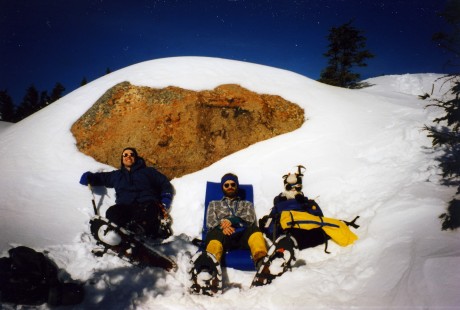
I thought I’d share some old photos of winter hikes. Perhaps by looking at them, you will feel warmer by comparison. All of them were taken in the White Mountains of northern New Hampshire.
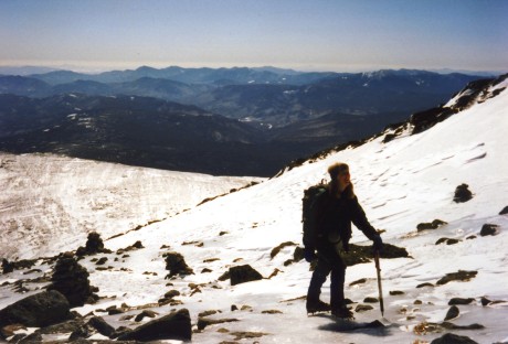
Winter hiking can actually be fun. We had a nice sunny day for this climb of Mt. Washington. No wind, and temps were above zero—not something you take for granted there in winter.
Conditions on a climb we did of Adams were really cold and windy.
We had “snow goblins” along the trail on a climb of Mt. Eisenhower.
Sometimes the trip was long hard work.
Oh, I forgot. This last one isn’t in the Whites. This is East Kennebago in western Maine—a bushwhack peak. I’m holding a moose horn we found.
Stay warm, and maybe spring will arrive one of these days!
Plants I’m fond of: Lapland rosebay (Rhododendron lapponicum) December 14, 2012
Posted by Jenny in hiking, plants, White Mountains.Tags: Boott Spur, Boott Spur Link, Lapland rosebay, Mt. Washington, Rhododendron lapponicum, Tuckerman Ravine
add a comment
I took this picture along the Boott Spur trail on Mt. Washington. It was in June, at an elevation of 5000′. I had just connected with this trail via the Boott Spur Link, which comes straight up from the floor of Tuckerman Ravine.
Although I’m not usually into “trail-bagging,” such as becoming a “900-miler” (doing all the trails in the Great Smoky Mountains National Park), one year I just happened to notice that I’d been on all the trails that take you up to the summit of Mt. Washington, directly or indirectly, except for Boott Spur Link. I thought I might as well fill in my “missing link,” especially since the steepness of the trail made it look interesting. (Its upper section climbs 500′ in about a quarter mile.)
Once I arrived on the broad Boott Spur ridge, I began to encounter pockets of Lapland rosebay nestled in among the screefields. You notice that the leaves have a downy texture. It’s as if they need to have a little extra fur to keep warm in that harsh environment. The headwall of Tucks still had snow at that point in the season. The photo below was taken on the same hike from the other side of the ravine.
Lapland rosebay grows only in isolated alpine environments, such as around Katahdin, Washington, and Marcy. It finds pockets of soil between the sharp-edged talus rocks to grow in. And during a brief period in early summer, it comes into its glory. Those beautiful flowers, although tiny in comparison with those of Rhododendron maximum and other more familiar species, are among the largest blossoms that you find in this environment.
As this article explains, the “felsenmeer” is a tough place for a plant to live in. But if you look closely at the wind-blasted stone piles of this northern above-treeline environment, you start to see how plants of all kinds thrive in the crevices, the tiny seeps of high streams, the leeward sides of boulders. I can’t help but see it as a metaphor for human life amidst adverse circumstances.
Failure at Raymond Cataract December 1, 2010
Posted by Jenny in bushwhacking, hiking, White Mountains.Tags: Huntington Ravine, Lion's Head, Mt. Washington, Ravine of Raymond Cataract, Raymond Path, Tuckerman Ravine
6 comments
I’ve always been intrigued by the idea of the Ravine of Raymond Cataract. It is a shallow ravine on the east side of Mt. Washington, located between two much more famous neighbors, Tuckerman Ravine and Huntington Ravine. You can see it quite clearly from the upper slopes of Wildcat. In the photo below from the Brad Washburn collection, you see the RoRC on the left and Huntington on the right.
Early editions of the AMC White Mountain Guide give directions for navigating up the ravine, while a 1992 edition in my possession says, “Raymond Cataract falls through a series of wild and beautiful cascades in the Ravine of Raymond Cataract, but brush has covered a former footway, so the cataract can only be reached by those intrepid explorers who are skilled in off-trail travel.” Editions more recent than that make no mention at all of travel up the ravine. (Recent guidebooks are so much more sensible than older ones.)
So, how on earth did I decide to give it a try on a late November day? I had just one day available for hiking in northern New Hampshire, and I was having trouble picking a destination. I’ve done all the 4000 footers in winter—although I should add that November, coming before the winter solstice, doesn’t count in the AMC’s official winter peakbagging rules. In some ways November is easier than winter (warmer temps, not much snow) and in some ways it is harder (lots of ice, tricky stream crossings, daylight hours shorter than Feb.-March). I was having trouble mustering up enthusiasm for anything, until I looked at a map, noticed the RoRC, and thought, “Aha!” Somehow the idea really grabbed me. I knew I wasn’t going to get all the way up the ravine (it would be stupid to try that solo in cold weather, anyway), but I thought I could get up to the lowest cascade. It was a climb of only about 300 vertical feet from the trail.
Just to make my hike even more peculiar, I decided that rather than going to the RoRC by the shortest route (Tucks fire road to Huntington Ravine trail to Raymond Path), I would start at the very beginning of the Raymond Path, which I had never been on before. So I set forth from Pinkham Notch along the Old Jackson trail to make a long zigzag route.
Since it’s been nearly two years since I’ve experienced the White Mountains with ice and snow, I enjoyed things that would probably seem pretty ho-hum otherwise.
The Old Jackson trail is part of the A.T., becoming used as a cross-country ski trail in winter. But despite the diamond-shaped metal ski markers on the trees, I would say Old Jackson has a ways to go before it’s skiable.
I took miscellaneous “nature shots.” That’s the term you use when there’s nothing very exciting in the picture.
There were quite a few footprints on Old Jackson, but when I made the sharp turn onto the Raymond Path, I saw that only one person had been on the path since snow had fallen. I was actually surprised to see even that set. Surely no one else would be doing the same thing I was. Perhaps it was an ice climber heading to Huntington who had been dropped off at the Auto Road? But that doesn’t make sense. Someone “redlining” all the trails in each month of the year?
There were open places along the way, probably old avalanche runouts. I could sense the presence of towering heights around me.
So I crossed the Huntington Ravine trail and continued on to the RoRC. And I started bushwhacking through the scrub and the blowdowns (pictured at top). After doing this for about fifteen minutes and traveling an exceedingly short distance, I thought to myself, “You know, I think this would be a fine day for going up into Tucks and taking some pictures!” And so I ignominiously retreated.
When I arrived at Hermit Lakes, it started to snow. Pretty hard. Not good weather for photography. So I trundled down the Tucks fire road and back to Pinkham Notch, where I had a fine bowl of chili. Forget about chili from Texas or the Southwest or any place like that. Mt. Washington has the best chili.
Oddly enough, I enjoyed my outing. I’ll try RoRC again—I think in summer. I suppose I should feel bad about not going up Lion’s Head or all the way to the summit, except that I’ve done it a number of times before.


