Spring in the Plott Balsams April 14, 2015
Posted by Jenny in hiking, nature, Southern Appalachians.Tags: bellwort, box tortoise, chickweed, Fisher Creek, fleabane, larkspur, Plott Balsams, showy orchis, trillium, yellow violet
4 comments

Fisher Creek, gateway to my favorite part of the Plotts.
Just to the southeast of the Smokies lie the Plott Balsams, my backyard mountains. The Plotts rival their more famous neighbors for the profusion of spring wildflowers. You’ll even find some plants here that you don’t see in the Smokies. For instance:

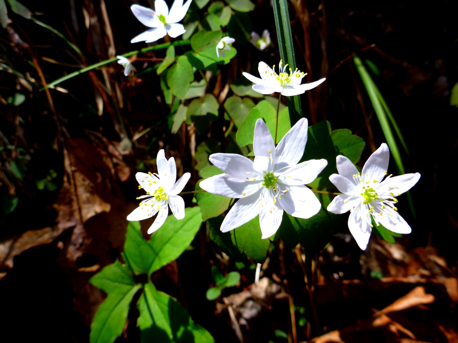
Larkspur (Delphinium).
On a showery afternoon, I headed up the East Fork trail. Soon I met a fellow creature who was also heading up the trail. I felt speedy by comparison.

What beautiful patterns and colors!
As I usually do, I went straight to the top without taking many pictures. It was completely socked in and spitting drizzle at the Fox Hunters Camp, my frequent destination for a good steep 2000′ climb. Up in the clouds, I moved through the temperate rainforest.

Everything is upholstered in moss.
On the way back down, I spotted a cluster of mixed white and red trilliums beside a little streamlet.

Just starting to open—in two different colors.

I always notice this small cascade, which runs beside a curved treetrunk.

Halberd-leaved yellow violet. One of the few violets that I can identify.

Trillium grandiflorum. You can also call it Great White Trillium, but somehow I like the Latin better.

Trillium and toothwort.

I have a weakness for unfurling ferns.

Chickweed.

Showy orchis.

A whole flock of large-flowered bellwort.
And near the end of my short hike, I saw this splendidly cheerful blossom.

Fleabane (Erigeron)—I think!
Spring in the Smokies April 11, 2015
Posted by Jenny in hiking, Life experience, nature, plants, Smoky Mountains, White Mountains.Tags: bloodroot, chickweed, ferns, hairy buttercup, Lapland rosebay, mayapples, rue anemone, trillium, violet, wild geranium
8 comments

Nodding trillium.
Hooray! I saw a trillium blooming today. As I started along my hike, I saw many trilliums that weren’t quite blooming yet. As I usually do, I go up the trail at a fairly good pace just for the aerobic benefits, and then as I come back down I stop and look more carefully and take photos. I kept thinking, “Somewhere I will see a trillium in bloom.”
As I got back down toward the trailhead, I was looking more and more closely among those unblooming trilliums. Surely I would find one at least that had erupted into blossom. Hate to say it, but I did not find it in some remote pristine area. It was almost back to my car. (Could the heat from my radiator have caused it to bloom? Ha, ha! No, not quite!) Actually, the woods near this trailhead are quite pretty.
To take the photo above, I very gently lifted the blossom on its stem and placed it atop one of the three leaves so that I could take its picture. (I couldn’t quite ask it to “say cheese.”) The trouble with nodding plants is that they hide from the camera. After I took the photo, I equally gently placed it back in the nodding position.
What follows is just a typical range of what you see in the Smokies in the miraculous month of April. I am not absolutely sure of all my plant identifications and I welcome corrections.
By the way, this place is not at all one of the famous Smokies wildflower spots. I won’t even tell you where it is (if anyone figures it out, I will be somewhat surprised). This is not Porters Flats with the carpets of phacelia, or Chestnut Top with its amazing variety.
This is just ordinary Smokies in spring.
Rue anemone.

Chickweed.

Hairy buttercup.

Violets. According to one source, there are 31 species of violets in the Smokies. I will not try to specify any of my violets.

One of these violets has a small insect enjoying itself.

Fuzzy new ferns.

Geraniums. An insect also visits here (the left blossom).

Violets next to a very small stream. I think the water is more interesting here than the flowers.

Ah! Another one I really wanted to see! A bloodroot.

A tiny, insignificant, beautiful stream. There are myriads of these in the Smokies.

Mayapples.

Bee and violet. So much life going on around us, nearly invisibly.
The life of the Smokies is so vibrant, so flourishing, so exuberant in its variety. I will soon be leaving this place for another world (northern New England) where the life of the plants has a very different aspect. There is not nearly so much variety. But it is an interesting story. The plant life in places like, say, the region above treeline on Mt. Washington has adapted in the most incredible ways to the harsh environment. I find that equally inspiring, in a very different way.
Below you see a plant that has adapted to a world where the wind can easily blow well over 100 mph in the winter (as you probably know, it blew 231 mph sometime up there on George in the 1930s, setting a world record). This is rhododendron! Smokies bushwhackers may laugh, having wrestled endlessly through giant rhodo. But here this little guy pops up amidst the above-treeline scree. A mini-rhodo! Don’t think bushwhacking in northern New England is easy. You have that belt of scrub spruce that girds the treeline area. And you have all the complicated aspects of snow and ice, especially the freakish ice formations that you find above treeline in winter.
I will be writing about these things on this blog.

Lapland Rosebay, found on the Boott Spur Link approaching the summit of Mt. Washington. Funny little thing, right? Don’t make too many assumptions!
Frowning Rock Ridge April 7, 2013
Posted by Jenny in bushwhacking, hiking, plants, Smoky Mountains.Tags: Bradley Fork, Dry Sluice trail, Frowning Rock Prong, Frowning Rock Ridge, geranium, hepatica, Hughes Ridge, mayapple, trillium
10 comments

Looking down Frowning Rock Ridge
Your faithful blogger goes places for you so that you don’t have to go there yourself. From the comfort of your armchair, you can visit the upper portion of Frowning Rock Ridge.
For some background on my obsession with the headwaters of Bradley Fork, go here. I’ll repeat one of the maps from that post, showing names that I gave to these very wild ridges that no one has ever visited, as far as I can determine:

Part of the headwater streams and ridges of Bradley Fork.
In its appearance, Frowning Rock Ridge is the strangest and most interesting of the ridges, to judge from the map. But I couldn’t even see it from any of the viewpoints I visited on my earlier trip of 24.6 miles and 5260 total vertical feet.
My altimeter came up with exactly the same figure today, even though I circled the watershed clockwise instead of counterclockwise this time—after I subtracted out my foray of 300 vertical feet down the ridge. It just so happens that the ridge joins with the A.T. at about 12 miles into the trip whichever direction you take, so it doesn’t matter whether you start with Bradley Fork and Hughes Ridge or with Dry Sluice trail and Richland Mountain.
Last night when I was preparing for the trip, I looked at a satellite image of the ridge at a higher magnification than I’d done before. It looked to me as though the ridge might actually be vegetated on nearly all of its crest even though it has huge slides going off to the left (west).

The wide slides come down the left side of the ridge into a draw.
It is hard to orient yourself with a satellite image. The draw to the west of the ridge almost seems to look like a ridge itself, but that reverses the ridge/valley structure. Two narrow slides come down to the same draw from the other side . . . but things have changed since this image was created.
More about the slides in a moment. For right now, let’s just say that when I looked closely at this image, I thought, “Well, that vegetation will make things safer for me when I explore down the ridge!” It did give me lots of stuff to hang onto. It also made the ridge virtually impenetrable.
After a brief period of spruce forest interspersed with witch hobble, it turned into what you see below.

I crawled through the jungle.
Every now and then, the way would be almost clear for a few feet.

It didn’t last.
I got glimpses of a pretty big slide to the right. This is different than what the satellite image shows.

Telephoto view of slide.
Much later in my outing, I had a glimpse of the area from the upper Bradley Fork trail. There is a huge slide that comes down from just west of Laurel Top—exactly what this might be the upper part of. Very intriguing. I wish I could have taken a picture of it, but from that standpoint, there was too much forest in between, and the light was bad.
From the ridge, I had views of what I call Fortress Ridge to the west and Fishtail Ridge to the east.

Fortress Ridge, with a heath-covered side ridge coming down.

Fishtail Ridge has some interesting exposed rock.
I wrestled with the rhodo and laurel for a while. It was pretty grim, and I saw no signs that it would let up any time soon. In fact, it got worse as the ridge grew narrower and steeper. Plus, I had to take into account the dimensions of my overall outing. So I turned around and crawled back up. Of course, the wind-blasted branches had all been aiming downslope, so to speak, so now I was going against the grain. Experienced bushwhackers will know what I mean.

Valley of Frowning Rock Prong from the A.T. close to the ridge.
I hadn’t seen anyone all day, but now I ran into a total of six thru-hikers. I had a burst of adrenalin from my mini-adventure, so I galloped past them all with my much lighter pack, turned down Hughes Ridge, and felt great until I hit the junction with the upper Bradley Fork trail. All of a sudden I felt horribly tired, and I still had 7.4 miles to go. I stopped, had something to eat, and pressed on.
It was pretty much of a death march from that point on. Fortunately, once down on the section of trail that goes along Bradley Fork itself, the flowers made a nice show. But I will say that I took all of the photos below at the beginning of the hike, not at the end. In my final miles, I was in that robotic mode where I didn’t even want to break stride to take a picture—and I knew ahead of time it was going to be that way. So below you will see some photos from early in the morning.

A lovely cluster of Trillium grandiflorum.

My first geraniums of 2013.

A carpet of phacelia.

Mayapples and phacelia.
I feel as though I don’t want to set foot on the lower Bradley Fork trail again for quite a while, but I do want to explore some of the slides in the headwaters area, possibly going out from Newfound Gap. For now, I will just daydream about it.
I don’t expect many people will be interested in this.

Hepatica with furry new leaves just starting to grow. It’s finally spring!

