Right fork of Trout Branch December 2, 2013
Posted by Jenny in bushwhacking, hiking, Smoky Mountains, winter hiking.Tags: Alum Cave Trail, Mt. LeConte, Trout Branch
13 comments

We looked back down from the top of the big waterfall.
I’ve been up Trout Branch maybe four or five times over the years, but I’ve always gone to the left at the major junction just below 4400′. Most times I’ve gone up what you might call the right fork of the left fork, the one that leads up to the Alum Cave trail directly below Cliff Top. Once I took the left of the left, which goes to the West Point ridge. The right fork was the only one I hadn’t explored.
I was accompanied by Cindy McJunkin and Chris Sass on this fine outing. They are great hiking companions. Chris and I have done a lot of hiking trips together, but this fall he’s been swamped with work at his teaching position at Young Harris College in north Georgia (he teaches math). He hadn’t been able to get out for a good bushwhack adventure since August… way too long. Cindy has been bitten by the off-trail bug in the past couple of years—she’s an experienced backpacker who’s put in a lot of mileage on the A.T.—so I was glad she was able to join this outing. Fellow female bushwhackers don’t come along all that often.
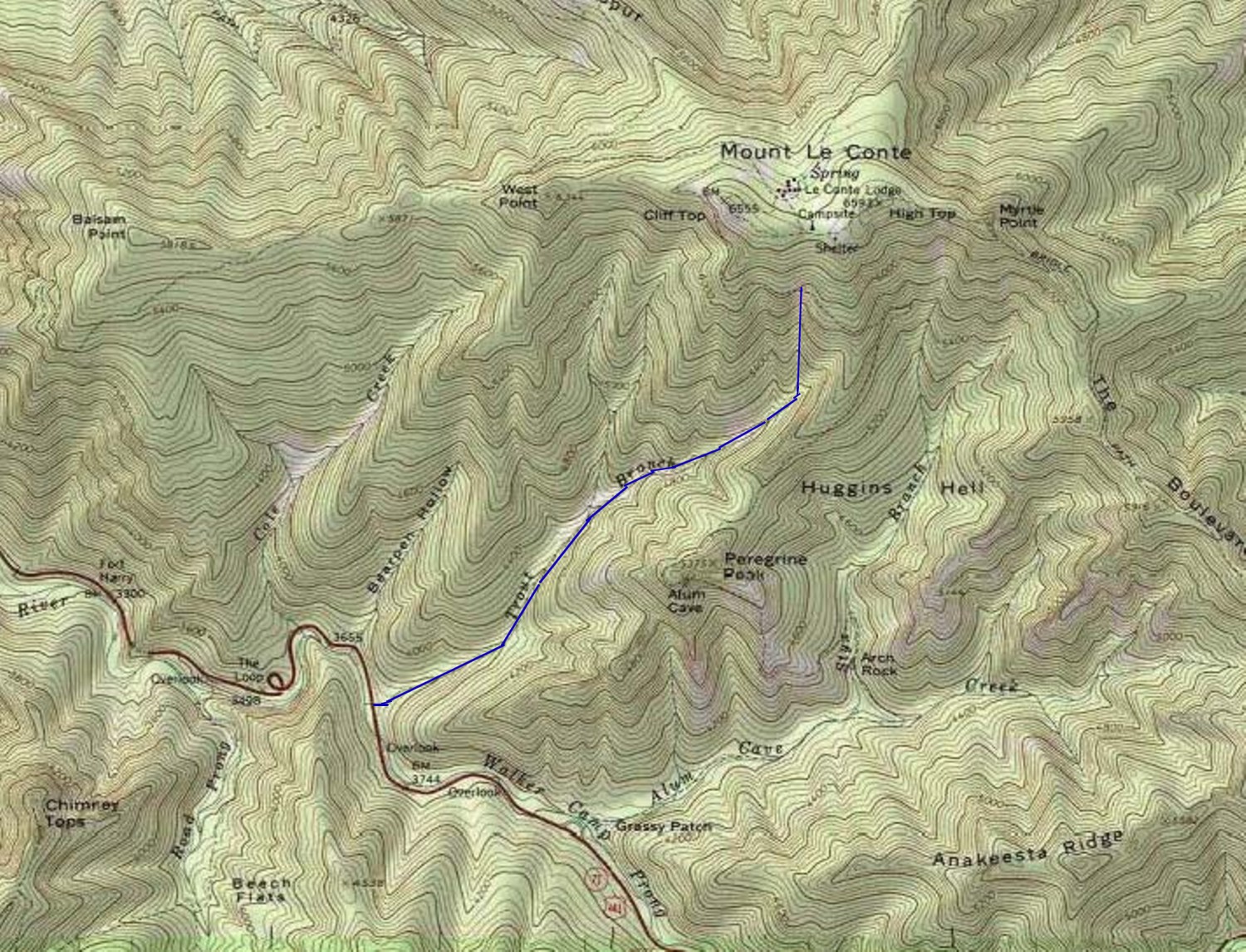
Our route up Trout Branch. It terminated at the trail, a dotted line hard to see on this map. Click for zoom.
We started a little after 9:00 and proceeded up the lower stream. Even in this photo you can see a hint of red discoloration on the rocks caused by landslide activity that exposed sulfuric Anakeesta bedrock.

Look closely, and you’ll see a faint reddish tint on some of the rocks.
As we got closer to the base of the big landslide, we could see patches of the “tomato soup” water that you encounter after these cataclysmic events. For photos of a trip up the slide, go here. Recent heavy rains have diluted the water.

Now we get into the “tomato soup.”
The logjam at the base of the slide is just amazing.

These were living trees up till the landslide, which snapped them off and stripped off the bark.

Bottom of the slide chute.
The slide is fun to climb in dry conditions. In the ice and snow we encountered this day, it would’ve been pretty challenging.
All along the stream I enjoyed the ice formations.

Snow and ice over water.
There is a particularly beautiful pool a little above the landslide junction.

- Chris approaches the pool.

A place of dreams and imagination.
We had a treat a little further along: paw prints in the snow.

- Bear prints in the snow.

The bear walked across the snowy log.
We saw a large waterfall ahead. In this photo you see the sunlight hitting the treetops above. We were in and out of sunlight in this stream valley.

This was a significant obstacle.
We did some serious rhodo thrashing to get around the waterfall and finally got to the top, where the photo at the top of this post was taken. We got into pitches of steep terrain.

Looking down the slope.
At around 5100′, several small valleys converge, some too small to show up on the map. At first we stayed with the largest, easternmost valley, but when we reached a point where it was clogged with blowdowns, we opted to follow a draw that angled to the left, going close to due north.

Cindy and Chris work their way up the valley.
We got into a fun bit of steep rock scrambling. When we reached smooth icy ledge we headed off to the right and got into steep spruce forest. From there it was a strenuous but straightforward climb up to the trail.
We’d thought we might cross the trail and continue upward along a valley that in days past was used as a descent route by LeConte Lodge workers. However, sunset comes so early these days that we opted to head down, and it was a good thing we did, for it was getting dark by the time we reached the lower sections of the Alum Cave trail. Can you believe it took us from around 9:15 to 2:30 to go something like two miles on the off-trail portion? If you figure we’re especially slow or inept, I invite you to try it for yourself, in similar conditions of snow and ice.
As we descended the trail, we met J.P. Krol, the winter caretaker of LeConte Lodge. Most likely he was entertaining himself with a trip down to Alum Cave Bluff.
A great hike with two fine bushwhacking companions.

Cindy took off her pack to squeeze under this log.
The 1000-foot scar November 8, 2012
Posted by Jenny in bushwhacking, hiking, Smoky Mountains.Tags: Alum Cave Trail, Big Duck Hawk, Peregrine Peak, Trout Branch
5 comments

James gazes up the scar toward sandstone bluffs exposed by the landslide
James Locke and I had set Wednesday as the day for a hike, and Wednesday it would be, regardless of the weather. When we met up at the starting point, a mixed precipitation was drizzling down, just on the edge between rain and snow. Up at Newfound Gap it was all snow, and the crew at LeConte Lodge were getting yet more new accumulation to offset partial melting that had occurred since last week’s big dump.
I’d been wanting to check out a huge new landslide scar route off Trout Branch that was pioneered by Greg Harrell. He didn’t just happen to notice it, he went out deliberately looking for new scars soon after hearing that LeConte had received six inches of rain in a day, early in August. Looking across from the Chimneys, he saw a brand-new jagged opening that extends all the way down from the 5200′ point on Alum Cave trail where it slabs around Peregrine Peak, down past Big Duck Hawk ridge and on to Trout Branch. Since then, he’s been up a couple times with other people. He and Chris Sass did a trip in late September, and Chris got some really nice photos that you can see here.
I especially recommend Chris’s photos because I had an embarrassing mishap with my camera as James and I climbed up the slide. After switching to heavier gloves, I accidentally set the camera in video mode, and it stayed that way the whole way up the interesting section. Duh!!! I ended up with a set of short, wobbly, substandard videos from each time I turned the camera on. The frame capture shown at top is the best I can offer. My apologies!
When we started up Trout Branch, we found patchy snow conditions in the surrounding woods and moderately high water.

Lower Trout Branch
At 4000′, we reached a distinctive tabletop boulder that marks the spot a couple of small stream basins join the main stem of Trout Branch. This is the place where the Smoky Mountains Hiking Club turned to climb up to Big Duck Hawk in July 2011.

The tabletop boulder at 4000′.
But things have gotten rearranged since then. You don’t really need to watch for the tabletop boulder, because just to your right is a giant pile of debris left from the landslide, trees heaped on top of each other, the bark peeled right off many of them. The force evidenced by this is simpy astounding.

You can make out the debris pile past where James is standing.

Awe-inspiring force is represented by this debris.
We climbed up the scar, reaching the interesting band of sandstone shown at top. Everything was stripped down to bare rock as high as 25 or 30′ up on both sides. It must have been a cataclysm.
In a couple of places we took to the woods on either side and found the amount of slushy snow deepening as we climbed, but nowhere above about knee deep. In the scar itself, the snow had mostly been washed away or melted. We crossed the geological boundary line to Anakeesta and found it to be a certain variety with lots of spiky textures that helped gaining a foothold but no clear strata as you find sometimes with this type of rock.
The way grew steeper in that classic progression of Smokies slopes, and up at the very top we had some tough scrabbling to get up an unstable slope of gravelly soil and loose rock. We came out on the Alum Cave trail just as a hiker passed by. The steepness was such that I had my hands on the edge of the trail right next to his feet starting to pull myself up, and he politely asked if I wanted a hand!
In the chilly, snowy conditions, we opted to hike down the trail rather than descending via Big Duck Hawk or some variation off of it. The fog was so thick that you could hardly see Alum Cave even when right underneath it, and Inspiration Point featured whiteness of an inspiring intensity. And so a short but fascinating hike ended.
Anakeesta Canyon September 16, 2012
Posted by Jenny in bushwhacking, hiking, Smoky Mountains.Tags: Alum Cave Creek, Alum Cave Trail, Anakeesta Ridge
13 comments

Descending the scar on Anakeesta Ridge.
One of the many things that I like about Greg Harrell is the way he gives names to every significant feature he encounters in his off-trail explorations of the Smokies. These names are always capitalized, and they are always used as if they carry as much weight as the official names you see on the USGS maps. And because of the way he uses those names, they do carry as much weight, as far as I am concerned.
And so it was decided between Greg, Chris Sass, and myself that we would visit the Anakeesta Canyon, traversing its upper bowl and going to Anakeesta High-Pass before descending the Anakeesta Scar. You will not find any of these place names on the official maps, although Greg did email us a copy of the Park Service map of the Smokies with the phrase “Anakeesta Scar Parking” and an arrow pointing to its location mysteriously added, in exactly the same typeface that is used in the rest of the map.
We left a car at this officially designated parking area and started our hike at the Alum Cave trailhead, leaving it before long to rockhop up Alum Cave Creek.

God beams over Alum Cave Creek.
It’s the second time I’ve rockhopped up Alum Cave Creek, and I’ve come to the conclusion that it’s impossible for a normal human being to keep their feet dry on it, even in the current conditions of very low water levels. It is completely hemmed in by rhodo on both sides, and it features frequent pools that fill the whole stream basin in such a way that it would take laborious rhodo-thrashing to go around them. That’s just too time-consuming, and Chris and I soon decided to just wade. I don’t know what Greg did. He was way up ahead of us.
(I will add that most of the time on this hike, Chris and Greg were up front and I was behind. They are both fast bushwhackers. I am a medium bushwhacker.)
After a while we caught up to him, sitting on a giant hemlock blowdown.

It couldn’t have been easy to get up on this high blowdown, but he did it.
Soon afterward, at 4450′, we left the main stream to make our way southeast up a tributary. It featured small bluffs and enough vegetation to keep things challenging. We noticed in many places along this side stream that the water had a reddish tint, apparently from iron oxide present in the Anakeesta rock.

Chris approaches a bluff with a blowdown leaning across it.

Typical Smokies off-trail stuff. If you don’t think you would like dealing with this, then you’d best stay away!

You don’t go super-fast in places like this.
Eventually we emerged into a high bowl of solid Anakeesta that got steeper and steeper. Just below the point where it got distinctly “cliffy,” we climbed onto a small side ridge for a break and some views.

Greg on the scar of the upper bowl.

Chris climbs into the bowl.

View from the side ridge.
After our break, we contoured southwestward across an alternating series of scars and vegetation-clogged side ridges. The idea was to hit Anakeesta Ridge at the distinct col between the 5582′ point and the 5988′ Anakeesta Knob.

We crossed a number of scars like this as we made our way toward Anakeesta High-Pass.
We could tell that we were close to the pass when we saw a skyline not far above us, and there we went straight up.

Final push up to the pass.
We took another break at the pass and shared entertaining anecdotes about our other hiking companions—a time-honored tradition.

Taking a break at Anakeesta High-Pass.

View down to the Newfound Gap road.
From there we did more traversing, except in the opposite direction and this time angling downward. We crossed more scars and more side ridges and eventually got down into the basin of a small tributary of Walker Camp Prong. Toward the bottom I discovered that I had a big rip in the seat of my pants. That must have been amusing for the people who drove by as we made the short walk alongside the highway up to the shuttled car. We also saw a couple of kids riding go-carts down the highway that were powered solely by gravity.
It was a great day.

View from the north side of Anakeesta Ridge.

