New Year’s hike up Styx Branch January 1, 2014
Posted by Jenny in bushwhacking, hiking, Smoky Mountains.Tags: Mt. LeConte, Myrtle Point, Styx Branch
8 comments

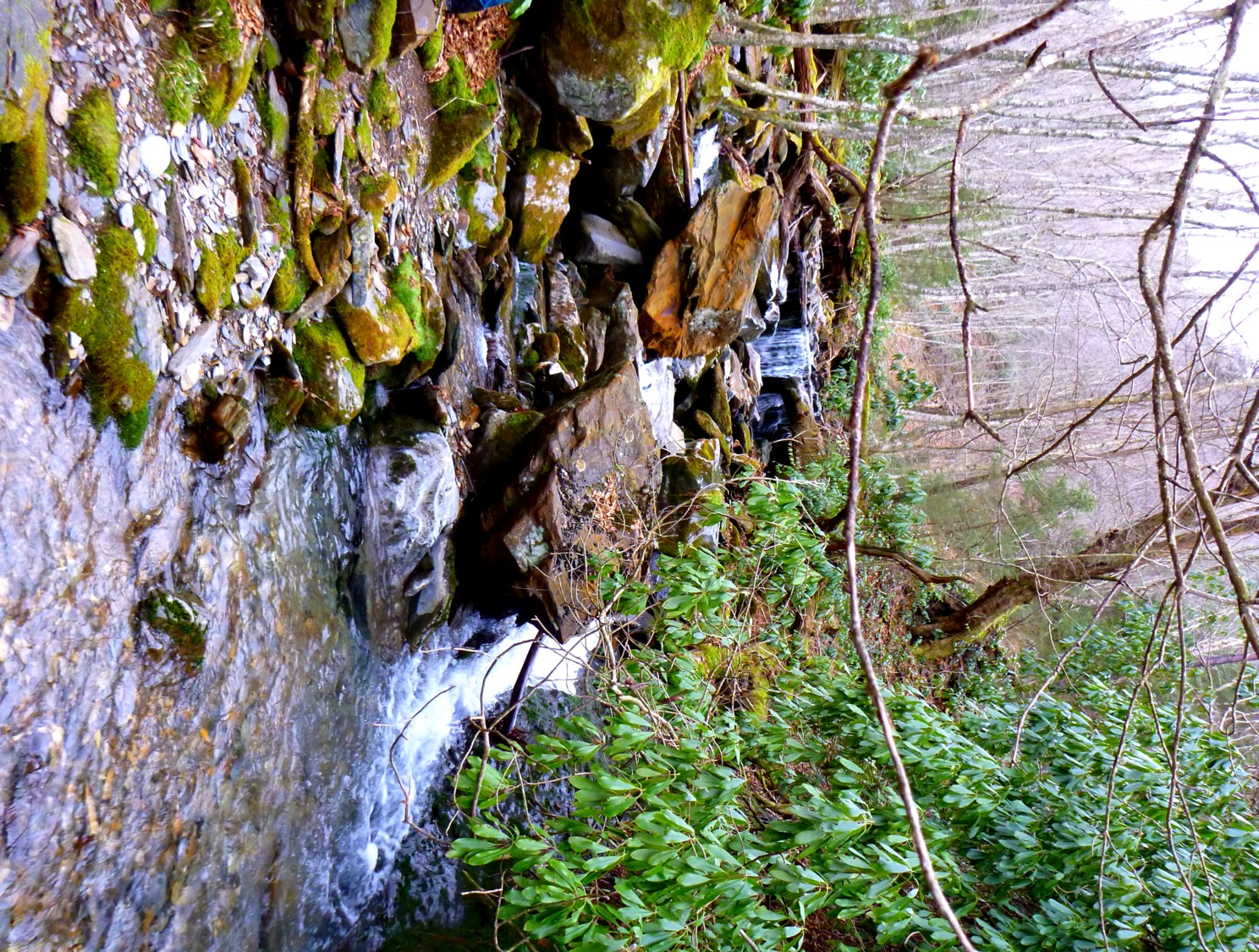
Icy cascade near a stream junction.
The year 2013 was, I have to say, objectively, one of the worst years of my life. The saving grace was completing the Twelve Streams of LeConte. I know this must come across as kind of a tease —“What happened to her this year?”—but I choose to keep this a mystery.
Going from December 31 to January 1 is, in a sense, meaningless, but by exerting imagination we can give these things symbolic importance. So, when my friend Cindy McJunkin suggested a New Year’s Day hike, it helped to dispel the gloom. I got her e-mail while I was up in Northampton, Massachusetts, visiting my sister. As usual, I spent my spare time up there doing short, steep hikes in the Holyoke Range. The picture below was taken on Christmas Day.

View from Mt. Holyoke to the Connecticut River.
The weather looked good for January 1, so we agreed to meet at the Alum Cave trailhead. And off we went up Styx Branch at the foot bridge above Arch Rock.
Styx shortly above the bridge.

The water dwindles here. It disappears higher up.
We turned up the left fork, which had no water at all this day, and climbed up to an area of blowdowns.

A lot of blowdowns in this stretch.

Cindy climbs a blowdown pile.
We encountered a lot of beautiful icicle formations.

Great icicles to the left.
As we got higher, we found that ice on the rocks made it difficult to climb up the rocks of the stream.

Here, water was flowing underneath the ice.
We reached a familiar junction where I had gone to the right a few times, past an imposing rock bluff. This time we stayed straight ahead. We climbed through an interesting mixture of grass and ice.

This was really great!
We started to have good views down the stream valley.

I always think of this as the halls of the mountain king.
We had a couple of slightly awkward manuevers around icy bluffs.

Above 6000′, you run into a few challenges.
We came out near the junction of the Myrtle Point side trail and the Boulevard trail. One of the many, many routes up Styx!
We proceeded to Myrtle Point for lunch. Then, the familiar descent via Alum Cave trail. One thing noteworthy: icicles were crashing down from Alum Cave Bluff in the thawing temperatures. We noted the line of shattered ice on the ground that marked the fall line from the bluff, and did our best to avoid lingering in that zone. We passed a couple who were taking pictures of each other in the fall zone holding icicles. I said, “You might want to move a little away from there,” but they didn’t pay any attention. Oh, well…
I’m very glad to have a new friend for sharing these adventures!

Cindy left, Jenny right. Two female bushwhackers.
Styx July 25, 2013
Posted by Jenny in bushwhacking, hiking, Smoky Mountains.Tags: Huggins Hell, Mt. LeConte, Myrtle Point, Styx Branch
15 comments
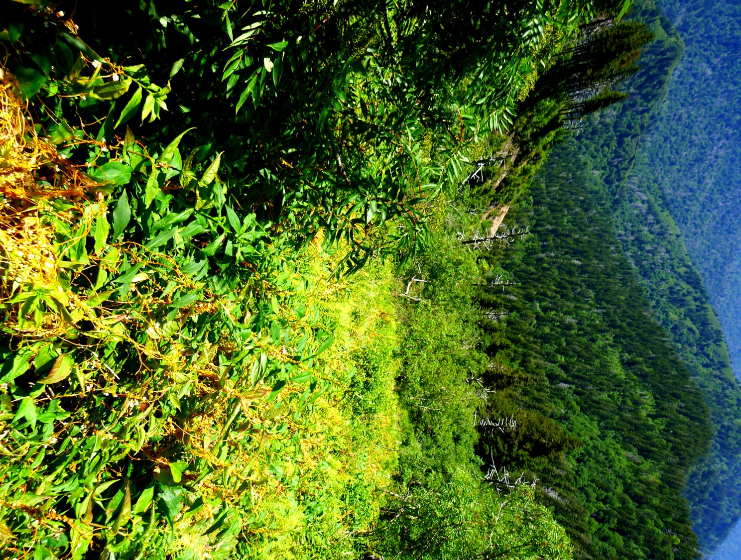
View from upper Styx Branch drainage. There’s something I don’t like in the foreground.
For the first time in weeks, the forecast for Gatlinburg said nothing about precipitation. I had to get out on this beautiful day!
So I climbed Styx Branch to Myrtle Point on LeConte. I’ve been up Styx four or five times via different routes—some accidental rather than intentional. This is the first time I’ve done it by myself. Readers may notice that lately I’ve been doing more solo bushwhacks than usual. I always enjoy hiking with my disreputable comrades, but this summer I’ve been in a mood to explore the feeling of being by myself in really wild places.
Yes, being a few hundred vertical feet below the popular tourist destination of Myrtle Point is a really wild place. Check it out sometime if you don’t believe me. From the bottom.
I hiked the familiar lower stretch of Alum Cave Trail until I reached the footlog above Arch Rock, then headed up Styx Branch. At the footlog, it carried a fair amount of water, but soon Styx lived up to its usual identity of a stream that often flows in subterranean paths, offering an unusually dry route for off-trail types. And you thought Styx got its name because it goes through Huggins Hell. No, it’s because it issues forth from diabolical realms far below the earth’s surface. That’s my story and I’m sticking to it.
I expected to see some new landslides after the recent phenomenally heavy rains, and I was not disappointed. Nothing super-dramatic, but noticeable.

New slide coming down from the Parton Peaks ridge.
I turned up the left fork and proceeded up the stream.

Small cascade on left fork of Styx.
I encountered the thickest, woolliest vegetation of any time I’ve been up in this area. Has the rainfall been saturated with Miracle-Gro?

A world of vegetation.
I also noticed that more blowdowns blocked the stream than I’d recalled from previous outings. As I’ve whined about on other recent blogs, the heavy rainfall and the thunderstorms seem to make it easy for trees to become uprooted.
I got into one particular spot that gave me ridiculous difficulty. It wasn’t dangerous, it was just incredibly awkward. One of those situations where one foot was on the slimy branch of a blowdown, the other foot on a slippery rock, and I was trying to leverage myself up by one arm—surely the push-ups I’ve been doing lately should help—and the branch I was leaning on snapped off.

Getting into the area of tall cascades.

Starting to make upward progress.

Saxifrage hangs over stream.

Now I’m in the halls of the mountain gods!

Looking down the draw.
I reached the perimeter of a big landslide area (not a new one—it’s been obvious for a long time). I climbed along the edge on steep gravelly soil and opted to move into pleasant open balsam woods.

Moss under balsams.
But when I saw a nice open meadow to my right, I traversed over to it. I was unpleasantly surprised to see that it was covered with a parasitical plant called dodder (which you also see in the top photo).

Cuscuta gronovii, better known as dodder.
It’s not one of those invasive plants that’s arrived in shipping crates just recently from overseas, it’s been around for a long time. My wildflower book says the Cherokees used it for medicinal purposes. Yet this is the first year that I’ve seen it in any quantity in the Smokies (if you’ve had a different experience, please let me know). I saw it last weekend along the A.T. near Mt. Cammerer, and now I see it all over the upper slopes of Styx, where I haven’t seen it before. Perhaps something to do with our bizarre climate this year?
It’s been around in the Black Mountains for a while, especially the northern Blacks like Celo Knob, where I saw tons of it on a traverse of the Blacks.
The wildflower book describes these vines as “parasitic annuals that lack chlorophyll. They attach themselves to a variety of host plants from which they derive nourishment through rootlike connections.” It’s also known as “love vine,” the book says. Funny! Mistletoe, another plant associated with love, is also parasitic. Hmmm . . . can anyone come up with a concept of love that doesn’t involve being a parasite?
I climbed steeply through these meadows of dodder, trying a route to the side that led to a combination of Rhododendron minus and Anakeesta bluffs, worked my way through, and popped out on the Myrtle Point side trail just steps away from the Point.
Some people came through just as I emerged from the brush. This time, oddly enough, they assumed that I was some sort of worker attached to the Lodge. Two separate groups both said something like “Thank you for your efforts” as I stood by the trail, removing my gloves, attempting to brush spruce and balsam needles from my clothing.
After this and my other recent experiences arriving on LeConte’s top, I’ve come to the conclusion that people can understand workers on the summit, but they cannot understand a person (especially a female on her own) bushwhacking just for the enjoyment of it. I responded to one of the groups, “What’s really nuts is that I do this for fun, not for a job.” I said I’d come up off-trail through the stuff they saw just to the side, but once again they had no questions for me along the lines of “What was it like?” or “Where did you start?”
Come to think of it, I didn’t see any other solo female hikers even on the Alum Cave Trail going down. I like to think of it as sort of a blank area of experience. In the end, I’m glad it’s that way.

View from Myrtle Point.
Above LeConte February 5, 2013
Posted by Jenny in nature, Smoky Mountains.Tags: Cannon Creek, Little Duck Hawk, Mt. LeConte, Myrtle Point, peregrine falcon
4 comments

Peregrine falcon
In dim swirls of sleep I dreamed I saw the top of Mt. LeConte from high above. In the way that dreams unfold without a pause or question, I knew I was a peregrine. I could hear the air flow evenly beneath my wings as I dipped to circle toward the mountain.
Sharp early-morning sunlight cast sheet-metal shadows. Every tree-furred valley folded neatly into place. Now I saw the streams that glimmered in the pouring light, the pools and waterfalls. I could see the water glide beneath the branching architecture of the trees.
As I banked and turned at Myrtle Point, I passed the glint of Cannon Creek. I saw its source quite clearly: tiny droplets percolating one by one from damp moss cushions in a balsam’s dark-blue shadow. I counted off LeConte’s twelve streams, turned sharp, and rode the air that flowed across the backs of mountains.
* * *

Little Duck Hawk, a nesting place for peregrines on Mt. LeConte

